

According to data from the United States Geological Survey, Tennessee has the ninth-most waterfalls of any state in the U.S. with over 500 naturally occurring waterfalls with distinct vertical drops. While many of these sit in the more mountainous eastern portion of the state, Middle Tennessee boasts a wealth of scenic falls.
Explore the beautiful terrain of Tennessee and discover these stunning waterfalls—spots to cool off on a hot summer day, or beautiful features to view any time.
Rutledge Falls
1276 Rutledge Falls Rd., Tullahoma, TN
Coffee County
38 miles from Murfreesboro
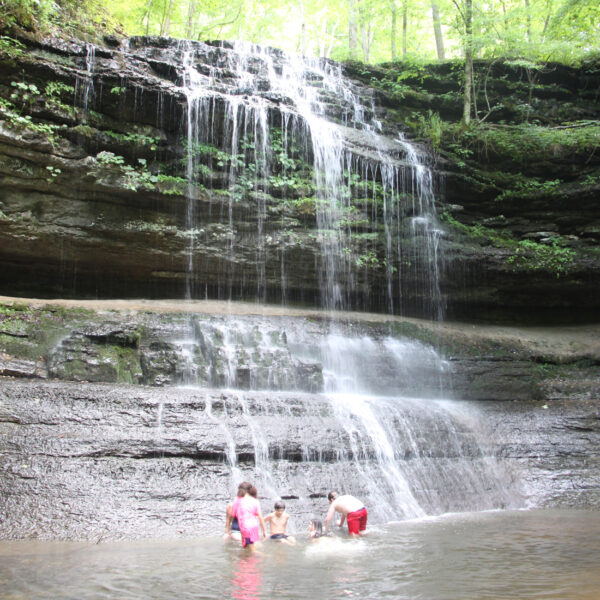
A few miles off of I-24 in Coffee County flows one of Middle Tennessee’s hidden gems. Though located on private property and not heavily promoted as a scenic tourist destination, Rutledge Falls remains open to the public during daylight hours.

Rutledge Falls is a beautiful sight: a waterfall, swimming hole and creek under a shady canopy of old trees. Even on the hottest of summer days, the water remains cold within the heavily shaded basin. Visitors are welcome to park in a small parking area just across from Rutledge Falls Baptist Church.
_____
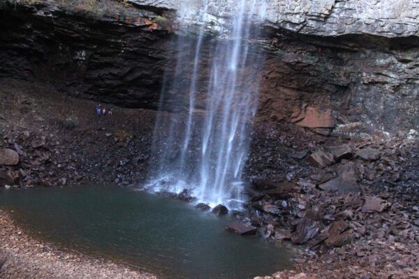
Machine Falls
Short Springs State Natural Area, 1 Powell Rd., Tullahoma, TN
Coffee County
41 miles from Murfreesboro
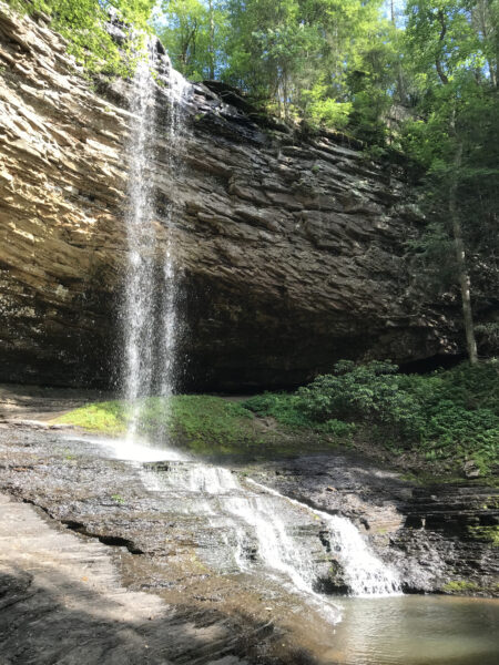
Machine Falls plunges 60 feet down a jagged rock face in a heavily wooded Tennessee holler only three miles from Rutledge Falls. Travelers to Machine Falls should prepare to get their feet wet during the final leg of the hike from the Short Springs Natural Area parking area in Coffee County; the last stretch to the falls requires walking upstream through the creek.
Arriving at the scenic feature, waterfall enthusiasts can climb up the rocks comprising the lower portion of Machine Falls, only approximately five feet, to a spacious ledge, with the majority of the falls above this point pouring down the rock face onto the large ledge. Nearby, boats on Normandy Lake can pull up and unload Machine Falls visitors as well.
_____
Greeter Falls
Savage Gulf West Trailhead, 555 Greeter Falls Rd., Altamont, TN
Grundy County
59 miles from Murfreesboro
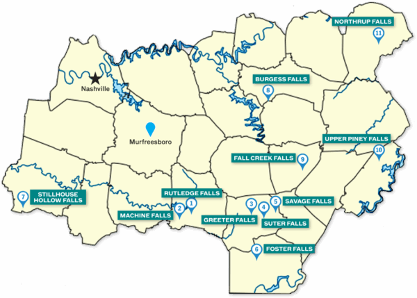
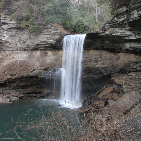
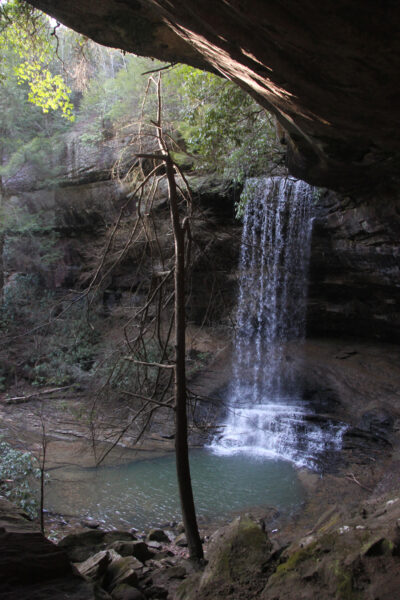
Tennessee’s Greeter Falls Loop trail leads to multiple scenic falls—Upper Greeter Falls, a striking 15-foot-tall feature of its own, and, after a descent down a big, metal, slightly slippery spiral staircase, the picturesque 50-foot-tall Lower Greeter Falls.
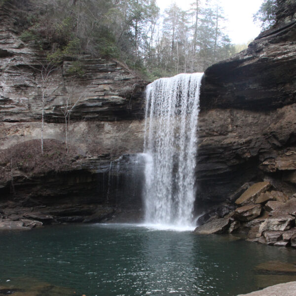
The very blue water in the plunge pool at the base of the lower falls can make for a fantastic swimming hole during hot times. The loop trail also leads past Broadtree Falls—nowhere nearly as impressive as Greeter, but another element of the Tennessee forest to view—and a short offshoot trail leads to the site of the old Greeter home place, where the Greeter family constructed a home in the 1880s.
_____
Suter Falls
Savage Gulf South Trailhead, 2689 55th Ave., Gruetli-Laager, TN
Grundy County
69 miles from Murfreesboro
Cascades move powerfully down a rocky gorge, rushing violently and loudly in an elbow shape around a bend after Rocky Mountain Creek plunges over Suter Falls, located within the Savage Gulf State Park. The spectacle of Suter Falls and the surrounding rocky cliff face is absolutely worth the brief but somewhat challenging journey from the Savage Gulf South Trailhead. In addition to this natural wonder, a trail veers off in between the trailhead and the waterfall, leading to an overlook offering a stunning view of the Tennessee wilderness.
_____
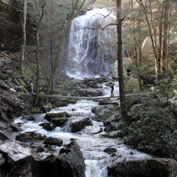
Savage Falls
Savage Gulf East Trailhead, 3157 State Route 399, Palmer, TN
Grundy County
74 miles from Murfreesboro
Setting out from the Savage Gulf East Trailhead, located within the expansive Savage Gulf State Park, can lead a group of waterfall seekers to Savage Falls. The 1.3-mile walk along the mostly level, well-maintained trail passes over two cable suspension bridges above creeks on the way to the falls. A staircase then leads down to the base of Savage Falls, an area with many large boulders scattered about. The small plunge pool can vary in depth based on water flow, but during periods of high water volume it can be suitable as a small swimming hole.
_____

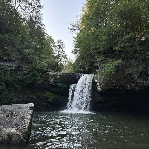
Foster Falls
Fiery Gizzard South Trailhead, 498 Foster Falls Rd., Sequatchie, TN
Marion County
70 miles from Murfreesboro
Located outside of Monteagle and Tracy City, the Little Gizzard Creek drops about 60 feet at Foster Falls into a wide, deep collection of water ideal for a serene, secluded swim in a natural setting. A view overlooking Foster Falls sits just a couple hundred yards from a parking area and, from here, a trail descending to the base begins. Stones have been arranged into a staircase throughout much of the trail and upon reaching the bottom, the massive pool is the reward on a hot day. The big swimming hole is approximately 150 feet wide and well over 10 feet deep throughout much of that width. Rock climbers also enjoy the Foster Falls site, located in Marion County, part of the South Cumberland State Park system.
_____
Stillhouse Hollow Falls
Stillhouse Hollow Falls State Natural Area, 8716 Lawrenceburg Hwy., Mt. Pleasant, TN
Maury County
71 miles from Murfreesboro
For a beautiful Tennessee waterfall with a small swimming hole, check out Stillhouse Hollow Falls, located between the towns of Columbia and Lawrenceburg. The trail to the falls, a shady .7-mile journey, travels alongside a creek, which presents a neat little 5-foot-tall waterfall itself. Enjoy this smaller water feature or continue walking down the shallow creek, or the trail, to get to the top of the larger falls. Stairs lead down the hillside, simplifying the descent to the base of the fantastic 75-foot-tall Stillhouse Hollow Falls, plunging into a pool that holds just enough water for an adult to fully submerge themselves with the surrounding area containing plenty of rocks on which to sit and dip feet into the cool water.
_____
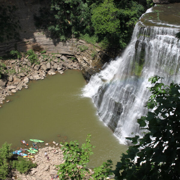
Burgess Falls
Burgess Falls State Park, 4000 Burgess Falls Dr., Sparta, TN
Putnam County
58 miles from Murfreesboro
Burgess Falls offers a spectacular sight as the 136-foot-tall waterfall on the Falling Water River plunges into the gorge below. Burgess Falls, located in White County, approximately 10 miles south of downtown Cookeville, is really a series of four waterfalls, with the final 136-foot feature being the most drastic drop. View all four areas on a half-mile hike at Burgess Falls State Park. Striking, gigantic rocky cliff walls encircle the basin of the main falls area, where kayakers and swimmers enjoy the pool of water below as onlookers observe from on top of the ridge. At one time, a staircase descended from the top of the falls into the gorge area. However, currently there is no upper-level access to the area below the falls. (The people in the water put in their kayaks and boats farther downstream the Falling Water River—which empties into Center Hill Lake—and traveled upstream.)
_____
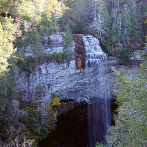
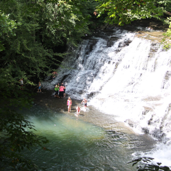
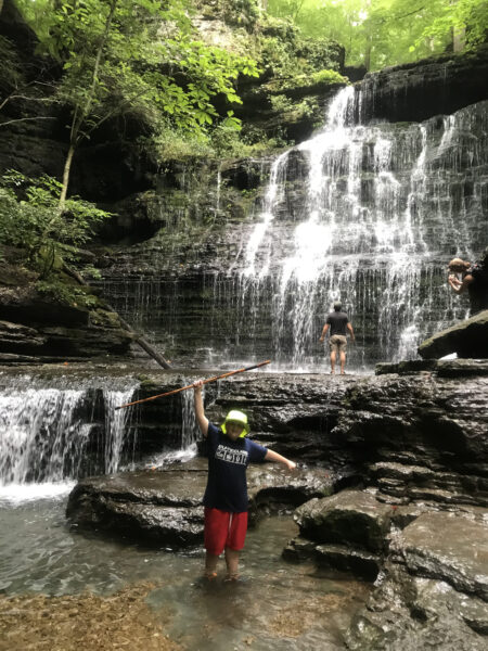
Fall Creek Falls
Fall Creek Overlook Parking Area, Fall Creek Falls State Park, 1664 Scenic Loop Rd., Pikeville, TN
Van Buren County
78 miles from Murfreesboro
The 256-foot-tall Fall Creek Falls is in fact the tallest U.S. waterfall east of the Mississippi River.
Motorists can drive right up to an overlook of the crown jewel of Fall Creek Falls State Park where all can behold the view of the falls from above. A half-mile trail leads down the hillside to the base of this unique natural spectacle. It obviously travels a significant change in elevation over this brief distance but, while steep at points, has helpful handrails for much of the way, and even stairs part of the way.
Feel the cool mist at the base, and those willing to get a little wet can circle the rocky bowl, which catches the waterfall, and let the water hit them. Otherwise, the state park—located about 35 miles east of McMinnville—is loaded with other creeks, gorges, animals, trees, cascades, swimming holes and attractions, a golf course, a lake, a lodge, a nature center, camping areas, playgrounds and bridges.
_____
Upper Piney Falls
Piney Falls State Natural Area, 1712 Firetower Rd., Grandview, TN
Rhea County
135 miles from Murfreesboro
A cool spray awaits those who venture behind Upper Piney Falls. The trek to both Upper and Lower Piney Falls, located at Piney Falls State Natural Area—in Rhea County, not far from Crossville—is not too difficult of a journey through the thick Tennessee woods, with only a few moderately steep inclines.
A unique waterfall and a great little swimming hole await those who complete the trip. A wide path actually leads visitors behind the 80-foot-tall waterfall, plenty wide enough to offer the option of getting wet, or not, as hikers walk between the falling water and the rock face. A cable trail runs up the steep hillside across the creek at the base of the falls for a more challenging hiking excursion.
_____
Northrup Falls
Colditz Cove State Natural Area, 2552 Northrup Falls Rd., Jamestown, TN
Fentress County
130 miles from Murfreesboro
Up on the Cumberland Plateau in the upper eastern edge of Middle Tennessee, Northrup Falls plunges 60 feet into its rocky pool within the Colditz Cove State Natural Area. The waterfall feature itself is quite spectacular—visitors can walk behind, or directly under, the falls—and as a whole, the natural area feels secluded and contains an interesting variety of terrain and plant life.
A 1.4-mile loop takes hikers to an overlook at the top of, and then the base of, Northrup Falls, where Big Branch Creek roars over a protruding rock ledge, creating a cave formation behind the falls. The plunge pool is not large enough for swimming, but it makes a fine spot to wade and splash.
_____


Thanks for this waterfall map. We cannot wait to visit them all!
Comment August 5, 2024 @ 2:02 am